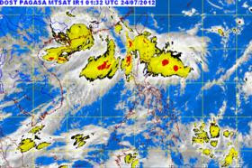
PAGASA Update - July 24, 2012
A new low pressure area (LPA) has formed east of northern Luzon, the state weather bureau said on Tuesday. A potential cyclone east of Luzon intensified early Thursday and it may linger in Philippine territory until
at least Sunday.
PAGASA said the new LPA was spotted 300 kilometers east of Tuguegarao, Cagayan.
PAGASA said the new LPA was spotted 300 kilometers east of Tuguegarao, Cagayan.
In case one of the LPAs intensifies into a cyclone, it will be named “Gener” once it enters the Philippine area of responsibility (PAR).
Meanwhile, the other LPA east of Mindanao “has remained almost
stationary for the past six hours” and was last spotted 910 kilometers
east of the region.
PAGASA said these two LPAs and the southwest monsoon (habagat) will bring scattered rains and thunderstorms over northern and central Luzon.
Northern Luzon areas were warned of possible flashfloods and landslides.
PAGASA said these two LPAs and the southwest monsoon (habagat) will bring scattered rains and thunderstorms over northern and central Luzon.
Northern Luzon areas were warned of possible flashfloods and landslides.

No comments:
Post a Comment